The North Atlantic Current (NAC) climate
cycle is comprised of approximately 100 Amazon rivers, and belongs
to the worldwide "salt conveyor" current that extends out to the
Pacific Ocean. NAC is primarily maintained by the cyclic process
of heat transfer where ocean currents that run in the North-South
direction reallocate heat from the equator to more temperate
zones. This redistribution of heat is further enhanced by the
movement of winds. As a result, warmer currents are able to
penetrate higher latitudes than usual. For instance, warm waters
flow up the north from the tropical zone as the Gulf Stream (which
travels eastward) merges into NAC. Europe becomes warmer during
the wintertime by about 9-18 degrees Fahrenheit due to the warmer
waters that flow up the Norwegian coast. The evaporation of the
NAC surface waters (aided by the cold, dry winds that come from
Canada in an eastward direction) causes NAC waters to leave their
salt sediments behind. This results in the sinking of the dense
surface waters which flow south, allowing for the "salt conveyor"
cyclical process to occur. The "salt-sinking" waters therefore
make room for warmer water to flow further north (which accounts
for the tolerable European winters, as mentioned earlier).
When this yearly flushing of salt-laden waters
halts, the "conveyor belt" is interrupted, in which the heat
transfer process is unable to travel northward. And here is where
the problematic issue of abrupt cooling arises. This failure of
flushing is signified by the absence of cooled surface waters
sinking and migrating southward while allowing warm waters to flow
northward. Several explanations are brought forward: 1) decreased
wind chill, 2) the presence of more floating ice, and 3) the
addition of fresh water to the ocean surface. The second point of
reasoning accounts for the North Atlantic Oscillation (a shift in
the atmospheric-cirulatory pattern over the North Atlantic, which
has commenced in 1996).
THE OCEAN: In the Pacific, the
North
Equatorial Current moves water from
East to West along the equator, where it is warmed by the intense
tropical sun. The water is then pushed North along the coast and
back East at higher latitudes, where it cools down before moving
South along the Eastern edge of the ocean with the
Humboldt
Current. As a result, the temperature
of the Western Pacific is up to eight degrees Celsius warmer than
that of the Eastern Pacific. At tropical latitudes, warm water is
accumulated in the Western Pacific to such a great extent that
there is actually a half-meter difference between sea levels in
Indonesia and Ecuador. A steep East-West thermocline
is created by this uneven distribution of
warm water.
Normal Conditions: Surface
Temperatures
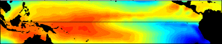
In this picture of surface temperatures in the tropical
pacific, you can see how warm water accumulates in the West
Pacific at during a normal year. Compare with El
Niño or La
niña.
The Pacific Thermocline is very deep in the
West and so shallow in the East that that off the coast of Peru
and Ecuador, there is a nutrient-rich upwelling of cold water from
below the thermocline. The upwelling is
crucial to the economies of these coastal nations because it
supports the fish population, the harvest of which is a big source
of export revenue for these countries.
THE ATMOSPHERE: The Easterlies,
also known as Trade Winds, are winds that blow from East to West
parallel to the North Equatorial Current. They help move water
Westward along the equator, while the Westerlies
blow water eastward at higher latitudes.
There are areas of higher and lower pressure
over the Pacific created by the Walker
Circulation (see
appendix for a picture of the Walker
Circulation). The air that arrives in
the West Pacific, having traveled with the Easterlies above the
ocean along the equator, is very warm and moist. Because it is so
warm, it rises over the West Pacific; this creates a permanent low
pressure area. When the air rises, it cools somewhat, and all the
moisture it is carrying condenses and falls as rain over the West
Pacific coast. As the air moves back East with the Westerlies, it
is cooled, and so sinks over the East Pacific, creating a high
pressure region with comparatively little rainfall. Whenever the
pressure on the West Pacific gets lower, the pressure on the East
Pacific gets higher and vice versa; it goes back and forth from
year to year and so is known as the Southern
Oscillation. The Southern Oscillation
is measured by the Southern
Oscillation Index (SOI), which is the
relative difference between the atmospheric pressures in Tahiti
and Darwin, Australia.
TO SUM UP: Under normal conditions, low
pressure, warm water, and heavy rains stay on the West Pacific
coast, while high pressure, cold water, and dry conditions prevail
on the East Pacific coast.